25th Annual Black Diamond Fall Fundraising Party
Thursday, September 13; 6:00-10:00 PM; Black Diamond Parking Lot

25th Annual Black Diamond Fall Fundraising Party
Thursday, September 13; 6:00-10:00 PM; Black Diamond Parking Lot
| Advisory: Ogden Area Mountains | Issued by Mark Staples for Monday - February 27, 2017 - 7:19am |
|---|
 |
current conditions Its snowing this morning over an inch per hour with about 5-7 inches in most places as of 6 a.m. Winds increased from the SW yesterday afternoon and were averaging 20 mph with gusts of 30-60 mph this morning. These winds will easily drift and transport the new snow as well as snow that fell from the last storm. Temperatures increased since yesterday and are mostly in the upper teens and low 20's F. Also - a few people noted some radiation recrystallized facets forming on the snow surface yesterday. Sunshine warms the snow a inch or two deep while the snow surface remains very cold. As the warm snow refreezes overnight, it forms a fragile ice crust with a thin layer of small, weak faceted crystals on top. These small facets shouldn't be a long lasting problem but should make wind slabs and storm snow avalanches easier to trigger today. Look for the thin ice crust as an indication that these small facets exist. |
 |
recent activity A few wind slabs were easily triggered yesterday on Ben Lomond Peak. One outlier avalanche was triggered by explosives at a ski area yesterday that broke 1-3 feet deep on new snow resting on an old ice crust from February 20th. Photo below of wind slabs that were easily triggered yesterday. Some were up to 20 inches deep. (K. Davis)
|
| type | aspect/elevation | characteristics |
|---|


|


|

LIKELIHOOD
 LIKELY
UNLIKELY
SIZE
 LARGE
SMALL
TREND
 INCREASING DANGER
SAME
DECREASING DANGER
|
|
description
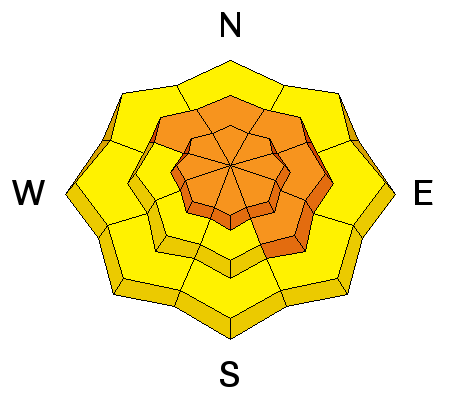
Strong SW winds and potentially heavy snowfall will form fresh wind slabs that will be easy to trigger today. If strong winds continue, some wind slabs could release naturally in the middle of the day. If winds ease today, continued snowfall will mask these winds slabs and make them harder to spot. Today will be a good one to ride great powder at lower elevations in terran sheltered from the wind. Wind slabs were breaking easily yesterday and should be even more sensistive today. Photo of wind slabs breaking at ski tips (K. Davis)
|
| type | aspect/elevation | characteristics |
|---|


|


|

LIKELIHOOD
 LIKELY
UNLIKELY
SIZE
 LARGE
SMALL
TREND
 INCREASING DANGER
SAME
DECREASING DANGER
|
|
description
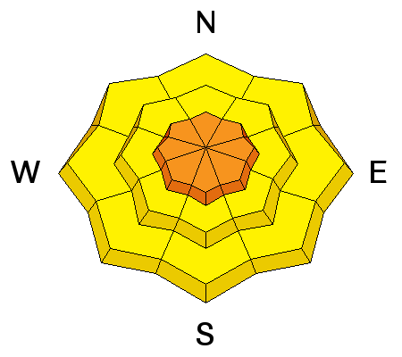
Today as new snow rapidly accumulates, avalanches could begin occurring even in non-wind affected terrain. Sluffing in the new snow will be a warning sign of a rising danger telling us that the new snow is not bonding well to itself or the old snow underneath it. Cracking in the new snow will tell you that a slab is beginning to form and storm slab avalanches could be triggered. If you find a fragile ice crust and small facets buried under the new snow (see note in Current Conditions), this avalanche problem will be even more sensitive. |
| type | aspect/elevation | characteristics |
|---|


|


|

LIKELIHOOD
 LIKELY
UNLIKELY
SIZE
 LARGE
SMALL
TREND
 INCREASING DANGER
SAME
DECREASING DANGER
|
|
description
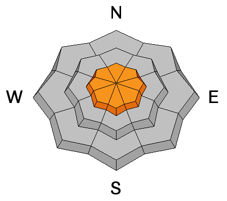
It's hard to predict when or where cornices will break. However, there are two things we know: They will be growing today with new snow and strong SW winds which will add more weight, thus adding more stress and making them more likely to break. We also know where they exist and can avoid being under or on top of them. |
 |
weather Snowfall will continue most of today with the heaviest snowfall ending this afternoon. Temperatures shouldn't warm as cold air enters the area and prevents day time warming. By the end of today, storm totals could easily be 1.5 feet of new snow or more. Upper Big Cottonwood Canyon was halfway to that total as of 6 a.m. Winds should slowly ease some, and blow 10-20 mph from the SW with gusts of 30 mph but remain strong enough to easily transport the new snow. |
general announcements
|