25th Annual Black Diamond Fall Fundraising Party
Thursday, September 13; 6:00-10:00 PM; Black Diamond Parking Lot

25th Annual Black Diamond Fall Fundraising Party
Thursday, September 13; 6:00-10:00 PM; Black Diamond Parking Lot
| Advisory: Ogden Area Mountains | Issued by Mark Staples for Wednesday - November 30, 2016 - 7:32am |
|---|
 |
current conditions This morning temperatures are in the mid teens F and winds are blowing 5-10 mph from the W and SW with gusts of 15 mph. Yesterday had NW winds blowing similar speeds and under mostly cloudy skies, temperatures reached the mid 20's F. With little wind, cloudy skies, and cold temperatures, great powder can be found on many slopes. Storm totals from Saturday through Tuesday morning in the Ogden mountains are 28" (2.59" of water) at 8000' and 8500'. |
 |
recent activity The most notable avalanche in the Ogden area was a slide a foot deep and 50 feet wide on a north facing slope at 8000' near Powder Mountain triggered by heavy machinery. This slide occurred Monday. Otherwise there were several slides triggered by explosives near Salt Lake City in Little Cottonwood Canyon. These broke 2-4 feet deep at the ground. This area had more early season snow than the Ogden mountains. |
| type | aspect/elevation | characteristics |
|---|


|


|

LIKELIHOOD
 LIKELY
UNLIKELY
SIZE
 LARGE
SMALL
TREND
 INCREASING DANGER
SAME
DECREASING DANGER
|
|
description
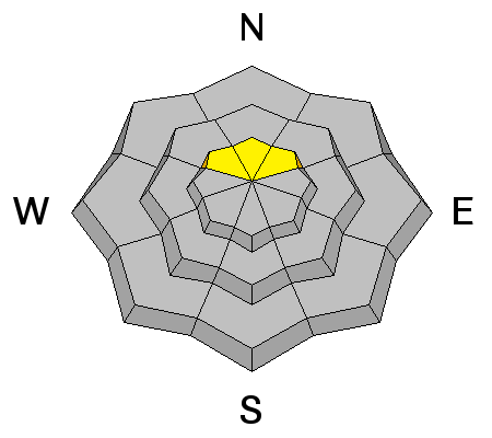
A dangerous, deep persistent slab avalanche problem exists on upper elevation North facing slopes or any slope that had old snow earlier this month. Many places in the Ogden mountains did not have enough early season snow or any snow at all to create this problem. However, it is worth looking for. One observer found this layer and it produced unstable results in stability test near Ben Lomond Peak (read ob HERE). Until we get a better sense of the distribution of this layer, it's best to dig to the ground and look for it, or avoid high northerly aspects all together. |
 |
weather Lingering moisture today will keep skies cloudy this morning with some snowflakes in the air but no accumulation. Skies will become partly sunny with temperatures reaching the low to mid 20's F. Winds will continue from the West blowing 10-15 mph. By tomorrow winds will shift to the NW bringing colder air and a more moisture which should only produce a few inches of snow. |
| general announcements Remember your information can save lives. If you see anything we should know about, please help us out by submitting snow and avalanche conditions. You can also call us at 801-524-5304, email by clicking HERE, or include #utavy in your tweet or Instagram. To get help in an emergency (to request a rescue) in the Wasatch, call 911. Be prepared to give your GPS coordinates or the run name. Dispatchers have a copy of the Wasatch Backcountry Ski map. Backcountry Emergencies. It outlines your step-by-step method in the event of a winter backcountry incident. If you trigger an avalanche in the backcountry, but no one is hurt and you do not need assistance, please notify the nearest ski area dispatch to avoid a needless response by rescue teams. Thanks.
EMAIL ADVISORY If you would like to get the daily advisory by email you will need to subscribe here. DAWN PATROL Hotline updated daily by 5-530am - 888-999-4019 option 8. TWITTER Updates for your mobile phone - DETAILS UDOT canyon closures: LINK TO UDOT, or on Twitter, follow @UDOTavy, @CanyonAlerts or @AltaCentral Utah Avalanche Center mobile app - Get your advisory on your iPhone along with great navigation and rescue tools. Powderbird Helicopter Skiing - Blog/itinerary for the day Lost or Found something in the backcountry? - http://nolofo.com/ To those skinning uphill at resorts: it is critical to know the resort policy on uphill travel. You can see the uphill travel policy for each resort here. Benefit the Utah Avalanche Center when you shop from Backcountry.com or REI: Click this link for Backcountry.com or this link to REI, shop, and they will donate a percent of your purchase price to the UAC. Both offer free shipping (with some conditions) so this costs you nothing! Benefit the Utah Avalanche Center when you buy or sell on ebay - set the Utah Avalanche Center as a favorite non-profit in your ebay account here and click on ebay gives when you buy or sell. You can choose to have your seller fees donated to the UAC, which doesn't cost you a penny.
|