| During the month of April, Mark Miller will donate $75 to the charity of your choice (5 to chose from, including the Utah Avalanche Center!) Mark Miller Subaru has raised over $300k in the previous 6 Do Good Feel Good events. More Info here |  |

For every car Mark MIller Subaru sells in April, they will donate $75 to the charity of your choice (5 to choose from). Who are you going to choose? Plus - you can vote for your favorite and the 3 groups receiving the most votes get an additional cash prize donated by Mark Miller Subaru. Details here

| During the month of April, Mark Miller will donate $75 to the charity of your choice (5 to chose from, including the Utah Avalanche Center!) Mark Miller Subaru has raised over $300k in the previous 6 Do Good Feel Good events. More Info here |  |
| Advisory: Ogden Area Mountains | Issued by Drew Hardesty for Sunday - February 2, 2014 - 6:33am |
|---|
 |
current conditions Clearing, cold, quiet wind, cold smoke. Temps are zero to the single digits, winds are light from the west and northwest, skies - now mostly cloudy - will thin out through the day with a weak and transitory ridge building overhead. A few more inches fell during the day yesterday - 2" here, 4" there - all quite variable from place to place with localized instability showers. Densities ranged from 2.5-4% of what they call Alta Champagne, or for you teetotalers out there - cold smoke. It'll be a 5 star day - get after it. |
 |
recent activity Activity centered on loose snow avalanching on the steepest (approaching 40 degrees and steeper) slopes with a sustained pitch. With such low density snow, naturals occur(ed) during peaks of high snowfall intensity in the early and later afternoon. |
| type | aspect/elevation | characteristics |
|---|


|


|

LIKELIHOOD
 LIKELY
UNLIKELY
SIZE
 LARGE
SMALL
TREND
 INCREASING DANGER
SAME
DECREASING DANGER
|
|
description
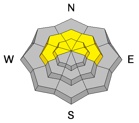
Loose snow sluffs will be easily triggered on the steeper (approaching 40 degrees and steeper) slopes of all aspects today on the mid and upper elevations. Keep you eye on the sun. If and when the sun comes out, it'll be a game changer. Just a little solar radiation is enough to start peeling off natural dry (and a few wet) loose sluffs on the sun-kissed terrain.
Travel Advice - Usually manageable avalanche conditions associated with higher levels of certainty for experienced snow travelers. Normal Caution is advised. Test slopes, ski cuts, previous tracks, and cornice drops may provide some level of information on stability. More prevalent at the higher elevations on all aspects (as depicted in the current avalanche forecast). Avoid this terrain or choose slopes gentler than 40 degrees in steepness. Give runout zones a wide berth when natural avalanches are expected or when others may be traveling above you. For more info on Travel Advice, click here. |
| type | aspect/elevation | characteristics |
|---|


|


|

LIKELIHOOD
 LIKELY
UNLIKELY
SIZE
 LARGE
SMALL
TREND
 INCREASING DANGER
SAME
DECREASING DANGER
|
|
description
One observer yesterday wrote Red Flags Comments: "Wishing there was a human factor/people red flag. Saw at least 30 different groups between 0700 and 1400. It appeared to be a rare moment when there were not people ascending and descending the same slope at the same time..." Agreed. I gave a talk last winter in the Tetons on what I called The Social Contract in the Backcountry. It outlined many very close calls and incidents from Sun Valley to Bozeman to Jackson to the Wasatch of folks unwittingly - some would argue negligently - triggering avalanches on top of others, on top of roads, and into exit gullies that can sometimes have the traffic of I-15. Without mindful skiing and riding, It only seems a matter of time before the schoolbus of kids gets knocked off the road or the picnic party oblivious to what's above gets buried. This includes cornice dropping, ski cutting, even center-punching a line. The Problem - Overcrowding and Perceived Freedom of the Hills (the backcountry is starting to look more like this - photo - Flagstaff, Little Cottonwood Canyon- ok actually Chilkoot Pass 1893 - the only difference is we're looking for "white gold")
The Solution: The Social Contract in the Backcountry
|
| type | aspect/elevation | characteristics | |||||||
|---|---|---|---|---|---|---|---|---|---|


|


|

LIKELIHOOD
 LIKELY
UNLIKELY
SIZE
 LARGE
SMALL
TREND
 INCREASING DANGER
SAME
DECREASING DANGER
|
|||||||
|
description
Though much of this has likely relaxed, it's still worth a mention - a few pockety booby traps of lingering persistent slab exist primarily in the 7-9000' range northwest to northeast facing terrain up to 16" deep. Provoked, a few of these released on the 30th and 31st...associated generally with facets around a rime crust formed Monday the 13th...Continue to give this "problem" respect by moving efficiently and safety through the terrain.
|
 |
weather We'll see partially clearing skies under a transitory weak ridge of high pressure. Wind will be light, temps will be in the single digits to mid teens. A storm dives to our south, but the northern "branch" pushes through late Monday into Tuesday that may bring an additional 4-8" of very low density snow...with additional light snowfall expected through the week. |
| general announcements
Remember your information can save lives. If you see anything we should know about, please participate in the creation of our own community avalanche advisory by submitting snow and avalanche conditions. You can also call us at 801-524-5304 or 800-662-4140, email by clicking HERE, or include #utavy in your tweet or Instagram. If you trigger an avalanche in the backcountry - especially if you are adjacent to a ski area – please call the following teams to alert them to the slide and whether anyone is missing or not. Rescue teams can be exposed to significant hazard when responding to avalanches, and do not want to do so when unneeded. Thanks. Salt Lake and Park City – Alta Central (801-742-2033), Canyons Resort Dispatch (435-615-3322) Snowbasin Resort Dispatch (801-620-1017), Powder Mountain Dispatch (801-745-3772 x 123). Sundance Dispatch (801-223-4150) EMAIL ADVISORY We have switched to a new SLC email advisory system. If you would like to get the daily advisory by email, or if you have been getting the advisory by email since the beginning of the season and wish to continue, you will need to subscribe here. DAWN PATROL Hotline updated daily by 5-530am - 888-999-4019 option 8. Twitter Updates for your mobile phone - DETAILS UDOT canyon closures: LINK TO UDOT Utah Avalanche Center mobile app - Get your advisory on your iPhone along with great navigation and rescue tools.uned. Wasatch Powderbird Guides Blog/Itinerary for the Day. Lost or Found something in the backcountry? - http://nolofo.com/ Discount lift tickets are now available at Backcountry.com - Thanks to Ski Utah and the Utah Resorts. All proceeds go towards paying for Utah Avalanche Center avalanche and mountain weather advisories. To those skinning uphill at resorts: it is your responsibility to know the resort policy on uphill travel. Some allow uphill travel and have guidelines, some don't. Contact the Ski Patrol at each resort for details. IMPORTANT: Before skinning at a resort under new snow conditions, check in with Ski Patrol. Resorts can restrict or cut off access if incompatible with control and grooming operations. Benefit the Utah Avalanche Center when you shop from Backcountry.com or REI: Click this link for Backcountry.com or this link to REI, shop, and they will donate a percent of your purchase price to the UAC. Both offer free shipping (with some conditions) so this costs you nothing! Benefit the Utah Avalanche Center when you buy or sell on ebay - set the Utah Avalanche Center as a favorite non-profit in your ebay account here and click on ebay gives when you buy or sell. You can choose to have your seller fees donated to the UAC, which doesn't cost you a penny. This information does not apply to developed ski areas or highways where avalanche control is normally done. This advisory is from the U.S.D.A. Forest Service, which is solely responsible for its content. This advisory describes general avalanche conditions and local variations always exist. |
Advisory Hotline: (888) 999-4019 | Contact Information