

| Advisory: Ogden Area Mountains | Issued by Evelyn Lees for February 6, 2013 - 6:58am |
|---|


Above 8,500 ft.
7,000-8,500 ft.
Below 7,000 ft.
|
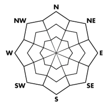
bottom line Areas of CONSIDERABLE avalanche danger remain on steep, upper elevation northwest through easterly facing slopes for triggering a deep avalanche failing on weak January facets. The avalanche danger is MODERATE for triggering a dry or damp snow slide on northwest through southeasterly facing slopes today at the mid elevations. Remember that areas of Low Danger don't mean no danger - avalanches can always be triggered in extreme terrain.
|
 |
special announcement There are a few spots left in the Women’s Avalanche class, with a Thursday evening lecture and Saturday field day. Groups will be divided by experience, so it’s appropriate for both beginners and more experienced backcountry travelers. Backcountry access closure in LCC for avalanche artillery testing today, Wed. 2/6/13 @ 4am between Lisa Falls and Monte Cristo. Please stay clear of the avalanche paths on North side of highway. Road closure between Gate B and Gate C starting at 10:00am, anticipated re-opening at 11:30am. |
 |
current conditions Clouds and a southwest flow kept temperatures warm overnight. Most stations are in the mid to upper 20s this morning, with a mid-elevation band near 8,000’ of above freezing temperatures. The winds are light, and in the process of shifting from the southwest to northwest. Any areas of dry settled powder will only be found on a wedge of northerly facing terrain, at mid and upper elevations. |
 |
recent activity There were no new avalanches were reported yesterday, though it was a fairly empty backcountry. Collapsing was still noted in the Provo area mountains. |
| type | aspect/elevation | characteristics |
|---|
 |


Above 8,500 ft.
7,000-8,500 ft.
Below 7,000 ft.
|
|
|
description
A winter with intermittent storms between long dry spells has left much of the Rockies and intermountain west with buried weak faceted layers in the snowpack. Our neighboring states have not been so lucky, with recent human triggered avalanches resulting in 3 fatalities, rather than amazing rescues. In Wasatch mountains of Utah, the persistent buried weak layers can still be triggered by a person, releasing a dangerous slide 1 to 3 feet deep and up to 200 feet wide. Both soft slab and hard slab avalanche possible, and could be triggered remotely. Travel on and below slopes of about 35 degrees and steeper facing northwest through east is not recommended. Taking the time to dig snow pits will show you the poor structure and stability tests that don't inspire confidence. |
| type | aspect/elevation | characteristics |
|---|
 |


Above 8,500 ft.
7,000-8,500 ft.
Below 7,000 ft.
|
|
|
description
Warm temperatures and clouds overnight resulted in a mid-elevation band of non-freezing temperatures. This will up the chances of triggering a damp sluff or even a wet slab today on mid and lower elevation slopes facing west through south east. Watch for wet surface snow or a punchy feeling, where there is wet snow beneath a surface slab. Avoid steep slopes with high consequences, where even a small slide could land you in a creek bed or strain you through trees. |
 |
weather The winds are shifting to the northwest this morning, and a cool, dry northwest flow will be over the area through tonight. Clouds will decrease and skies should clear by this afternoon. 10,000 foot temperatures will cool throughout the day, from the mid-20s into the upper teens. Highs at 8000’ will be in the low to mid 30s today. The northwesterly winds will be light, averaging less than 15 mph at most stations, with gusts only in the low 30s even across the highest peaks. Ahead of the next storm system, winds will shift back to the southwest on Thursday. Snow should begin late Friday, first on a southerly flow, though eventually the flow will shift to the northwest. Storm totals of 8 to 14 inches possible Friday through Sunday, with snow rates generally less than 1” per hour. |
| general annoucements Go to http://www.backcountry.com/utah-avalanche-center to get tickets from our partners at Park City, Beaver Mountain, Canyons, Sundance, and Wolf Mountain. All proceeds benefit the Utah Avalanche Center. If you trigger an avalanche in the backcountry - especially if you are adjacent to a ski area – please call the following teams to alert them to the slide and whether anyone is missing or not. Rescue teams can be exposed to significant hazard when responding to avalanches, and do not want to do so when unneeded. Thanks. Salt Lake and Park City – Alta Central (801-742-2033), Canyons Resort Dispatch (435-615-3322) Ogden – Snowbasin Patrol Dispatch (801-620-1017) Powder Mountain Ski Patrol Dispatch (801-745-3773 ex 123) Provo – Sundance Patrol Dispatch (801-223-4150) Dawn Patrol Forecast Hotline, updated by 05:30: 888-999-4019 option 8. Twitter Updates for your mobile phone - DETAILS Daily observations are frequently posted by 10 pm each evening. Subscribe to the daily avalanche advisory e-mail click HERE. UDOT canyon closures UDOT at (801) 975-4838 Wasatch Powderbird Guides does daily updates about where they'll be operating on this blog http://powderbird.blogspot.com/ . Remember your information can save lives. If you see anything we should know about, please participate in the creation of our own community avalanche advisory by submitting snow and avalanche conditions. You can also call us at 801-524-5304 or 800-662-4140, or email by clicking HERE Donate to your favorite non-profit –The Friends of the Utah Avalanche Center. The UAC depends on contributions from users like you to support our work. For a print version of this advisory click HERE. This advisory is produced by the U.S. Forest Service, which is solely responsible for its content. It describes only general avalanche conditions and local variations always exist. Specific terrain and route finding decisions should always be based on skills learned in a field-based avalanche class. |