AVALANCHE WARNING »
Dangerous avalanche conditions are occuring or are imminent.
Backcountry travel in avalanche terrain is not recommended.
|
 |
Notice: A Special Avalanche Advisory continues for the mountains of Utah with a particular Warning in the Logan area mountains. Deep unsurvivable avalanches may be triggered on a variety of aspects and elevations. We have had three avalanche fatalities in the backcountry this last week alone…Those without expert level avalanche skill should avoid being on, under, or adjacent to steep slopes. |
|
|
SPECIAL ANNOUNCEMENT |
 |
Unfortunately, Stace Fleming, 48, of Morgan, died Sunday. Our condolences to his family and friends. He was caught and buried in a large avalanche on Grandview Peak on Friday. (Read the complete investigation) We would like toacknowledge the heroic effort of the Wasatch Powderbird Guides, who happened to be skiing in the area. Steve Hall, a guide with the Powderbirds, landed when he noticed fresh debris and a person waving for help. He found the victim with his beacon within a minute and organized a very rapid recovery despite a very deep burial of 5.5 feet. Wasatch Powderbird Guides have led rescue efforts in the backcountry on many occasions through the years and we would like to personallyacknowledgetheir efforts. |
|
|
BOTTOM LINE
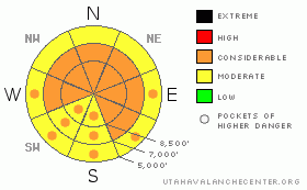
Danger by aspect and elevation on slopes approaching 35° or steeper.
(click HERE for tomorrow's danger rating)
|

Danger Rose Tutorial
|
We have a dangerous, unmanageable situation in the backcountry. The danger is CONSIDERABLE with deep, unsurvivable avalanches breaking near the ground. These can be triggered on, below or adjacent to these steep slopes. Also, the danger of wet avalanches will rise to CONSIDERABLE today with daytime heating. Avoid the steep sun-expose slopes by mid-morning. |
|
|
CURRENT CONDITIONS |

|
Light snow lingers on in the wake of a nice little storm that dropped about a foot in the Cottonwoods, 5-8” in the Provo and Park City mountains, 12-15” in the Ogden mountains, and up to 2’ in the Logan mountains. Densities averaged 5-8%. The westerly winds averaged 15mph with gusts to 25 overnight, but have since dropped to less than 20mph at all locations. Temps are in the low teens up high and near 20 degrees at the mid-elevations. Riding conditions with the cold smoke are primo and safe on slopes less steep than 30 degrees. Important! Ensure that you’re not below or attached to something steeper. |
|
|
RECENT ACTIVITY |

|
The new snow, particularly in wind affected terrain, ran often and easily with cornice drops and slope cuts. Most accounts had the new snow bonding poorly to the old snow surfaces, with at least skier remotely triggering the new snow 70’ away. The soft slab broke 12” deep and 40’ wide, running 350’ down the slope. The low density snow sluffed easily with human provocation in the steep, more sheltered terrain. These issues will persist today, particularly when the sun comes out.
The deep slab issues will be here for awhile. An experienced skier in the south fork of Provo canyon, the third descending the 33 degree pitch, collapsed the slope, with 75’ wide cracks opening 3’ deep. The southeast facing slope at 9000’ didn’t run, as the hard slab was reported not to have been attached to anything steeper. |
|
|
THREAT #1 |

|
| WHERE |
PROBABILITY |
SIZE |
TREND |

|
|
|
|
| |
|
|
Over the next
24 hours.
|
|
|
The primary concern centers around the overall structure of our snowpack. Weaknesses start at the foundation and continue to the floor level. It involves the west through north through southeast aspects, particularly – but not limited to - the mid and upper elevations. It’s like the X factor in the climbing ratings – if you blow it, you’re seriously injured or dead. Most of us have little trust in the slopes that did not natural last weekend or have not yet been triggered. Avoidance is the key. Remember that these hard slabs may pull way back onto the lower angled slopes or back onto ridgelines. Previous tracks offer no assurances. |
|
|
THREAT #2 |

|
| WHERE |
PROBABILITY |
SIZE |
TREND |

|
|
|
|
| |
|
|
Over the next
24 hours.
|
|
|
The storm snow may still be sensitive to human weight on a variety of steeper, wind drifted slopes. Patchy old-snow surface weaknesses, primarily across the shady side of the compass, may allow for the continuation of slides to be triggered at a distance. |
|
|
THREAT #3 |

|
| WHERE |
PROBABILITY |
SIZE |
TREND |

|
|
|
|
| |
|
|
Over the next
16 hours.
|
|
|
The new snow will be particularly sensitive to solar warming. Natural wet sluffs and very-easy-to initiate wet sluffs and slabs will become likely by mid to late morning and they’ll likely run fast and far in the low density snow on the old crusts. I expect to see a fair amount of wet activity on the steep sun-exposed terrain today. |
|
|
MOUNTAIN WEATHER |

|
Snow showers will soon taper off as the storm moves off to the east. We’ll see clearing skies, light westerly winds, and temps rising to the upper teens at 10,000’, and near 30 degrees at 8000’. A splitting system follows for mid-week with the northern branch affecting northern Utah by about Thursday. |
|
|
GENERAL ANNOUNCEMENTS |
This winter’s Snowbird fundraiser for the Utah Avalanche Center will be a relaxed, après-ski party Saturday, February 6, from 4:30-7. Hours d’oeuvres, beer, wine, music and a silent auction. Golden Cliff, Cliff Lodge, $50. For more info and to purchase tickets, click HERE
Discount Lift tickets: Ski Utah, Backcountry.com, Alta, Deer Valley, Park City, The Canyons, Wolf Mountain, Snowbasin, Beaver Mountain, Brighton, Sundance, and Solitude have donated a limited number of tickets for sale at discounted prices.
Wasatch Powderbird Guides flight plan.
Dawn Patrol Forecast Hotline, updated by 05:30:888-999-4019 option 8.
Daily observations are frequently posted by 10 pm each evening.
Free UAC iPhone app from Canyon Sports.
Subscribe to the daily avalanche advisory e-mail click HERE.
UDOT canyon closures UDOT at (801) 975-4838
We appreciate all your avalanche and snow observations. You can also call us at 801-524-5304 or 800-662-4140, or email to uac@utahavalanchecenter.org
Donate to your favorite non-profit – The Friends of the Utah Avalanche Center. The UAC depends on contributions from users like you to support our work.
The information in this advisory is from the U.S. Forest Service, which is solely responsible for its content. This advisory describes general avalanche conditions and local variations always occur.
I will update this forecast tomorrow morning. Thanks for calling. |
|
|
This information does not apply to developed ski areas or highways where avalanche control is normally done. This advisory is from the U.S.D.A. Forest Service, which is solely responsible for its content. This advisory describes general avalanche conditions and local variations always occur. |
|
This advisory provided by the USDA Forest Service, in partnership with:
The Friends of the Utah Avalanche Center, Utah Division of State Parks and Recreation, Utah Division of Emergency Management, Salt Lake County, Salt Lake Unified Fire Authority and the friends of the La Sal Avalanche Center. See our Sponsors Page for a complete list. |

