25th Annual Black Diamond Fall Fundraising Party
Thursday, September 13; 6:00-10:00 PM; Black Diamond Parking Lot

25th Annual Black Diamond Fall Fundraising Party
Thursday, September 13; 6:00-10:00 PM; Black Diamond Parking Lot
| Advisory: Moab Area Mountains | Issued by Eric Trenbeath for Sunday - February 12, 2017 - 6:53am |
|---|
 |
special announcement |
 |
current conditions The mountains picked up a decent dose of high density snow yesterday afternoon and evening, with Gold Basin reporting 6" of new. Geyser Pass Trailhead is reporting 4" with .5" of water. This shot of dense snow will provide a nice cushion over the old snow surface, and skiing and riding conditions will be greatly improved. Southwest winds during the storm were relatively well behaved, averaging 15-20 mph with gusts near 30 along ridge tops. They shifted to northerly a little after 6:00 p.m. and dropped into the single digits. They are currently light out of the SE. Temperatures are almost wintry again, it's 23 degrees on Pre-Laurel Peak, 26 in Gold Basin, and 30 at the Geyser Pass Trailhead. Reed Kennard was out yesterday and submitted this observation. Wind, temperature and humidity on Pre Laurel Peak. (11,700') Storm totals and temperature in Gold Basin. (10,000') Snow totals, temperature and snow/water equivalent at the Geyser Pass Trailhead. (9600') |
 |
recent activity |
| type | aspect/elevation | characteristics |
|---|


|


|

LIKELIHOOD
 LIKELY
UNLIKELY
SIZE
 LARGE
SMALL
TREND
 INCREASING DANGER
SAME
DECREASING DANGER
|
|
description
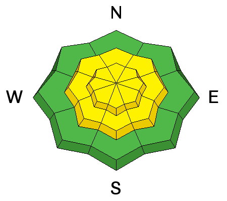
New snow amounts aren't great, and I think most of the instabilities will have settled out by this morning, but you may be able to trigger a long running, loose snow sluff, or cohesive soft slab on slopes steeper than about 35 degrees. Mostly manageable, these types of avalanches could nevertheless sweep you off your feet, and carry over a cliff, or into trees if they caught you unawares. |
| type | aspect/elevation | characteristics |
|---|


|


|

LIKELIHOOD
 LIKELY
UNLIKELY
SIZE
 LARGE
SMALL
TREND
 INCREASING DANGER
SAME
DECREASING DANGER
|
|
description
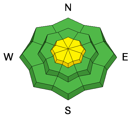
With plenty of loose, new snow available for transport, it won't take much of an increase in winds to form fresh wind slabs in upper elevation, wind exposed terrain. If winds do pick up, be on the lookout for fresh drifts of wind deposited snow on leeward slopes in upper elevation terrain. |
 |
weather Today look for mostly cloudy skies and a chance for lingering snow showers. 1 to 2 inches are possible. High temps at 10,000' will be near 32. East southeast winds will be from 5 to 15 mph, becoming southerly in the afternoon. |
| general announcements Road conditions: The road to Geyser Pass Trailhead is plowed with a mix of packed snow, dirt, and mud at lower elevations. If you are getting out into the mountains, we love to hear from you! You can SUBMIT OBSERVATIONS ONLINE If you would like to have avalanche advisories emailed to you, SIGN UP HERE Support the Utah Avalanche Center just by buying groceries! Do you buy groceries at City Market? When you register your Kroger rewards card with their Community Rewards program, they will donate to the Utah Avalanche Center whenever you make a purchase. It's easy, only takes a minute, and doesn't cost you anything. Details here. Benefit the Utah Avalanche Center when you shop from Backcountry.com or REI: Click this link for Backcountry.com or this link to REI, shop, and they will donate a percent of your purchase price to the UAC. Both offer free shipping (with some conditions) so this costs you nothing! The information in this advisory is from the US Forest Service which is solely responsible for its content. This advisory describes general avalanche conditions and local variations always occur. |