BOTTOM LINE
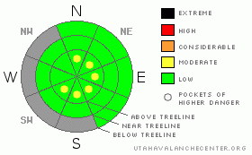
Danger by aspect and elevation on slopes approaching 35° or steeper.
(click HERE for tomorrow's danger rating)
|

Danger Rose Tutorial
|
The BOTTOMLINE for today in the La Sal and Abajo Mountains will be an Avalanche Danger of LOW with isolated pockets of MODERATE at and above tree line on slopes greater than 35 degrees that hold unsupportable wind slabs.
The biggest concern for back country skiers or snowmobilers is the significant lack of snow that effectively doesNOT cover rocks, stumps and logs. These hazards make travel difficult in most areas except on FS roads and grass covered meadows.
When weather gives you blue skies and sun in the desert; cross country, skate and peak climbing will be your best pursuits in the mountains during this significantly warm and dry early winter. |
|
|
CURRENT CONDITIONS |

|
There were a few lucky souls on Saturday that enjoyed a rare event this season in the mountains of southeast Utah, it just dumped snow for about five minutes and then, the storm was over. Only a 1/2-1" of snow fell in the La Sal Mountains and the Abajos got shined as the weak storm rolled through the Wasatch, Uintas and then into northern Colorado.
To add insult to injury, the wake of the storm left us with strong winds and low relative humidities which is sublimating our meager snow off of ridges. Once the wind stops howling, the sun will take over snow removal duty as high pressure once again settles over our area.
15" of snow sits at the Geyser Pass TH while Camp Jackson holds 21" in the Abajos. |
|
|
RECENT ACTIVITY |

|
No new avalanche activity. |
|
|
THREAT #1 |

|
| WHERE |
PROBABILITY |
SIZE |
TREND |

|
|
|
|
| |
|
|
Over the next
48 hours.
|
|
|
Anyone that is venturing out into territory that holds wind slabs will have a lot more to content with as well (ie safe, snow covered travel routes). There are wind slabs out there, in isolated locations, that could be reactive so be careful. |
|
|
MOUNTAIN WEATHER |

|
@ 10,000' in the La Sal Mountains, Utah
Today: Sunny, with a high near 32. Northeast wind between 5 and 10 mph.
Tonight: Mostly clear, with a low around 16. Northeast wind between 5 and 10 mph.
Monday: Sunny, with a high near 40. North northwest wind around 5 mph.
Monday Night: Mostly clear, with a low around 21. North northwest wind around 5 mph.
Tuesday: Sunny, with a high near 40. North wind around 5 mph becoming west southwest.
Tuesday Night: Partly cloudy, with a low around 21.
Wednesday: Mostly sunny, with a high near 34.
Wednesday Night: Partly cloudy, with a low around 18. |
|
|
GENERAL ANNOUNCEMENTS |
The Utah Avalanche Center in Moab has an AIARE Level I Avalanche Class scheduled for February 3rd-5th. If this weather pattern keeps up, we will have to cancel the class. We will make the final decision late in January. |
|
|
This information does not apply to developed ski areas or highways where avalanche control is normally done. This advisory is from the U.S.D.A. Forest Service, which is solely responsible for its content. This advisory describes general avalanche conditions and local variations always occur. |
|
This advisory provided by the USDA Forest Service, in partnership with:
The Friends of the Utah Avalanche Center, Utah Division of State Parks and Recreation, Utah Division of Emergency Management, Salt Lake County, Salt Lake Unified Fire Authority and the friends of the La Sal Avalanche Center. See our Sponsors Page for a complete list. |


