

| Advisory: Logan Area Mountains | Issued by Toby Weed for December 4, 2012 - 8:21am |
|---|


Above 8,500 ft.
7,000-8,500 ft.
5,000-7,000 ft.
|
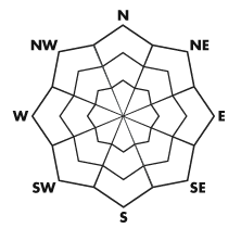
bottom line There is a MODERATE danger today on drifted upper elevation slopes facing north through east. Heightened avalanche conditions exist, and you could trigger wind slab avalanches on steep drifted upper elevation slopes above around 8000' in elevation . Evaluate the snow and terrain carefully, especially on upper elevation slopes with preexisting snow.
|
 |
current conditions The Tony Grove Snotel reports 6 inches of heavy snow containing a bit over an inch of water from Sunday The site reports 21 inches of total snow, 70% of normal for the date, and it's 30 degrees at 8400' . The Tony Grove Road is not maintained for winter travel and was very slick and icy on shady sections before last night's snowfall. Be sure you are prepared with shovels and other emergency supplies if you attempt the drive. There are lots of pedestrians and dogs on the upper portion of the road these days, so please keep an eye out and the speed down.
|
 |
recent activity Observers noticed a couple fresh wet point releases or sluffs on the steep western side of Tony Grove Lake Sunday, 12-2.... |
| type | aspect/elevation | characteristics |
|---|
 |


Above 8,500 ft.
7,000-8,500 ft.
5,000-7,000 ft.
|
|
|
description
Strong south winds accompanied heavy snowfall yesterday evening, likely creating sensitive drifts or wind slabs in exposed terrain. You are likely to trigger dangerous wind slab avalanches at upper elevations today, so you should avoid steep slopes with accumulations of drifted snow. Slopes near ridge-tops with developing cornices are obvious ones to avoid, but wind slabs also likely formed in and around terrain features like gullies, scoops, sub-ridges, cliff bands, and rock outcroppings.. On some slopes, the slabs formed right on top of weak sugary snow called near surface facets, and we can expect a lingering danger in these areas....
|
| type | aspect/elevation | characteristics |
|---|
 |


Above 8,500 ft.
7,000-8,500 ft.
5,000-7,000 ft.
|
|
|
description
Triggered loose surface sluffs or point-release avalanches and shallow soft slab avalanches are possible on steep slopes with preexisting snow cover. With very shallow snow cover, this is not a good time to be taken for a ride through the sharp rocks or down and dead trees that currently plague local avalanche run-out zones. |
 |
weather . A warm front will bring cloudiness and a little more snowfall to our area starting this afternoon, and accumulating snowfall at upper elevations is in the forecast through Wednesday night... Temperatures during this time frame will remain fairly mild so the rain/snow line will likely remain fairly high.... A more potent storm is expected for the weekend, but details are still a bit sketchy at this point. Check out the Logan Mountain Weather page...
|
| general annoucements Donate to your favorite non-profit –The Friends of the Utah Avalanche Center. The UAC depends on contributions from users like you to support our work. Remember your information can save lives. If you see anything we should know about, please participate in the creation of our own community avalanche advisory by submitting snow and avalanche conditions. You can also call us at 801-524-5304 or email by clicking HERE. In the Logan Area you can contact Toby Weed directly at 435-757-7578. This advisory is produced by the U.S. Forest Service, which is solely responsible for its content. It describes only general avalanche conditions and local variations always exist. |