Check out our Holiday Auction

Forecast for the Logan Area Mountains

Toby Weed
Issued by Toby Weed on
Thursday morning, April 1, 2021
The avalanche danger is LOW in the backcountry this morning. Mountain temperatures are much warmer than they were yesterday however, and MODERATE danger with elevated wet avalanche conditions will develop on steep sunny slopes later today. People could trigger wet avalanches and natural activity is also possible this afternoon on very steep sunny slopes, especially near cliffs or rock bands where the snow surface is soft and saturated.

Evaluate the snow and terrain carefully today as temperatures rise rapidly and the snow softens up and gets slushy.
Low
Moderate
Considerable
High
Extreme
Learn how to read the forecast here
Special Announcements
Thank you to everyone who helped make our Spring Campaign a huge success. We are grateful for your donations and what they will allow us to accomplish next season. We look forward to continuing to serve you with our forecasting, education, and awareness programs in new and exciting ways.
Weather and Snow
About an inch of dusty yellow snow fell and was drifted into camouflage patterns of white and yellow at upper elevations by Monday's strong winds. It's 30°F and there is 63 inches of total snow containing only 74% of normal SWE at the 8400' Tony Grove Snotel. I'm also reading 30°F and southwest winds are blowing around 20 mph at the 9700' CSI Logan Peak weather station. Cold temperatures early in the week solidly set up the snow which had become warmed, softened, and saturated over the weekend. Solar warmth today will soften the surface snow once again, and create elevated wet avalanche conditions on steep sunny slopes. A high pressure system will dominate the weather, and mountain temperatures will continue rise dramatically each day through Saturday when 9000' temperatures could reach 60°F !
Spring has hit the Cache, and we expect mountain temperatures to soar this week as a strong high pressure system sets up over the region.
Recent Avalanches
Lots of people made it out into the backcountry last weekend and only a few encountered avalanche issues:
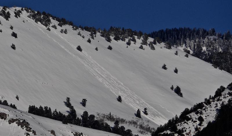
  1. A couple skiers tried a run on the Folly in Logan Dry late in the day Saturday (3-27-2021). and triggered manageable wet sluffs that created a sizable pile of debris visible from across Cache Valley. The Folly faces southwest and the top of the slope is a little above 9000' in elevation.
  2. One party reported intentionally triggering four soft wind slabs, 1 to 1.5' deep and 30 to 40 feet wide in extreme north facing terrain (chutes running through cliffs) at upper elevations in the Central Bear River Range on Friday, 3-26-2021.

I took this photo from my front porch in West Logan at 6:30 Saturday evening... 2 skiers showed Cache Valley that people could indeed trigger wet sluffs entraining large piles of saturated surface snow in sunny terrain.
Ad
Avalanche Problem #1
Wet Snow
Type
Location
Likelihood
Size
Description
  1. Loose wet avalanches are possible this afternoon on steep sunny slopes, especially near cliffs or rock bands where the snow surface is soft and saturated.
  2. Large, overhanging ridge-top cornices have grown recently, and people might be fooled into getting too close to the edge. Cornices tend to break back further than you might expect.

Here is Mark's take on the current situation;
Additional Information
General Spring Travel Advise:
As daytime temperatures rise, softening the snow, the danger of wet avalanches will increase, so its a good idea to get in the habit of an early start and to plan on heading down before things get too sloppy.
-Watch for trees or other terrain traps below you if you venture onto steep slopes.
-If you start sinking deeply into wet snow, or if the snow you are traveling on becomes unsupportable due to the heat, it's time to leave.
Do you have the essential avalanche rescue gear (transceiver, probe, and shovel) and do you know how to use them? Watch this video to see how the three pieces of equipment work together. HERE

Please keep practicing with the Beacon Training Park at the Franklin Basin Trailhead. Test yourself and your riding partners. It is free, fun, and easy to use.
General Announcements
Visit this website with information about Responsible Winter Recreation by the Utah Office of Outdoor Recreation.
EMAIL ADVISORY. If you would like to get the daily advisory by email you subscribe HERE.
Remember your information can save lives. If you see anything we should know about, please help us out by submitting snow and avalanche observations....HERE. You can also call us at 801-524-5304, email by clicking HERE, or include #utavy in your Instagram, or @UAClogan on Twitter.
We will update this forecast by around 7:30 Friday morning.
This forecast is from the USDA Forest Service, which is solely responsible for its content. The forecast describes general avalanche conditions and local variations always occur.