Check out our Holiday Auction

Forecast for the Logan Area Mountains

Paige Pagnucco
Issued by Paige Pagnucco on
Monday morning, March 29, 2021
There is a MODERATE avalanche danger today in the backcountry at upper elevations for triggering a fresh slab of wind drifted snow. These wind slabs will be generally shallow and isolated to terrain features like the lee sides of ridges, sub-ridges, and gullies. Avoid steep slopes with freshly wind drifted snow. Getting caught in even a small avalanche today could send you on a dangerous "slide for life" ride as the snow surface is smooth and frozen solid.

EVALUATE SNOW AND ESPECIALLY TERRAIN CAREFULLY TODAY
Low
Moderate
Considerable
High
Extreme
Learn how to read the forecast here
Special Announcements
Spring Awareness Campaign - Help us save lives through avalanche forecasts and education. Consider making a donation to show your support. HERE
Weather and Snow
It's 36°F this morning at the 8400' Tony Grove Snotel, and there is 64 inches of total snow containing 76% of normal SWE. It's 33°F and southwest winds significantly increased overnight and are now blowing around 40 mph, with gusts in the 60-70's at the 9700' CSI Logan Peak weather station. Snow showers are expected before noon today with 1-3" accumulation and temps will plummet from yesterday's balmy 40's to the teens by late morning. Strong winds will continue and shift from the southwest to the northwest this morning blowing 25-30 mph with stronger gusts possible.
Avalanche problems today will be limited to shallow wind slabs as there is not much snow to move around. The more concerning problem will be "slide for life" conditions as the snowpack refreezes with a smooth solid surface. If you plan an alpine adventure carrying an ice axe and crampons might be a good idea.
Today will be generally very cold and windy in the mountains. This system is short-lived though as sunshine returns tomorrow and temperatures return to seasonal norms by the end of the week.

(Logan Peak weather)
Recent Avalanches
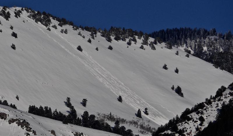
During our travels Sunday, we were able to easily initiate shallow wet loose sluffs on steep features by midday as the temperatures rose and the sun warmed the snow surface. No other reported activity.
A couple skiers tried a run on the Folly in Logan Dry (SSW @ 9000') late in the day Saturday and triggered manageable wet sluffs that created a sizable pile of debris visible from across Cache Valley.

One party reported intentionally triggering four soft slabs, 1 to 1.5' deep and 30 to 40 feet wide in extreme north facing terrain at upper elevations in the Central Bear River Range on Friday, 3-26-2021.


I took this photo from my front porch in West Logan at 6:30 Saturday evening... 2 skiers showed Cache Valley that people could indeed trigger wet sluffs entraining large piles of saturated surface snow in sunny terrain.
Ad
Avalanche Problem #1
Wind Drifted Snow
Type
Location
Likelihood
Size
Description
  1. Southwest winds increased dramatically overnight with gusts as high as 73mph on Logan Peak. Fortunately, with the weekend's warm temperatures, there is not a lot of snow to move around. Today's storm will bring light precipitation with 1-3 inches of snow forecast. Snowfall coupled with strong winds will create small wind slabs on leeward facing terrain mostly near the ridge tops and in and around terrain features like sub-ridges, gullies and cliffs. Avoid steep slopes with wind drifted snow. Wind pockets look smooth and rounded and will feel somewhat stiff and hollow underfoot. Even a small wind slab avalanche could send you for a dangerous "slide for life" ride on the smooth frozen snow surface.
  2. Large, overhanging ridge-top cornices have grown in recent days, and people might be fooled into getting too close to the edge. Stay well back from the edge as cornices tend to break back further than you expect.
Additional Information
General Spring Travel Advise:
As daytime temperatures rise, softening the snow, the danger of wet avalanches will increase, so its a good idea to get in the habit of an early start and to plan on heading down before things get too sloppy.
-Watch for trees or other terrain traps below you if you venture onto steep slopes.
-If you start sinking deeply into wet snow, or if the snow you are traveling on becomes unsupportable due to the heat, it's time to leave.
Do you have the essential avalanche rescue gear (transceiver, probe, and shovel) and do you know how to use them? Watch this video to see how the three pieces of equipment work together. HERE

Please keep practicing with the Beacon Training Park at the Franklin Basin Trailhead. Test yourself and your riding partners. It is free, fun, and easy to use.
General Announcements
Visit this website with information about Responsible Winter Recreation by the Utah Office of Outdoor Recreation.
EMAIL ADVISORY. If you would like to get the daily advisory by email you subscribe HERE.
Remember your information can save lives. If you see anything we should know about, please help us out by submitting snow and avalanche observations....HERE. You can also call us at 801-524-5304, email by clicking HERE, or include #utavy in your Instagram, or @UAClogan on Twitter.
We will update this forecast by around 7:30 Wednesday morning.
This forecast is from the USDA Forest Service, which is solely responsible for its content. The forecast describes general avalanche conditions and local variations always occur.