Sign Up for the Utah Snow and Avalanche Workshop (USAW) on December 7th!

Forecast for the Uintas Area Mountains

Andrew Nassetta
Issued by Andrew Nassetta on
Friday morning, November 22, 2024
Updated Friday, November 22nd at 04:00 PM
The snowpack is still very thin and the main game in the Uinta’s is avoiding rocks, stumps, and lumps barely hidden beneath the snow surface. If you're looking in the right place, you may be able to find a small lingering wind-drift in upper elevation terrain. Although small in size, even a little piece of moving snow could knock you off your feet and lead to a nasty ride.
Low
Moderate
Considerable
High
Extreme
Learn how to read the forecast here
Special Announcements
Save the Date | Saturday, December 7 | 17th Annual Utah Snow and Avalanche Workshop (USAW) | Information and tickets are available here.
Weather and Snow
Nowcast
Calm winds with a few scattered clouds have held on throughout the majority of the day. Ahead of the incoming storm, temperatures sit warm at 40 F at 10,000’, and closer to 50 F at many of the Uinta trailheads.
Forecast
Temperatures stay mild heading into the early portion of the weekend with averages around 30F.
Southwest winds increase early Saturday morning, gusting into the 40’s by day's end, ahead of a significant winter storm that arrives around sunset.
Futurecast
The storm has two main waves to look for. The first impulse gets going in full swing on Sunday and I’m cautiously optimistic we’ll stack up 7”-12” of snow, with up to 1” of SWE for Monday morning’s commute. A quick lull in the action is followed by the next system ramping up early Tuesday morning, with periods of heavy snowfall continuing Tuesday night into Wednesday.
Snowpack and Travel
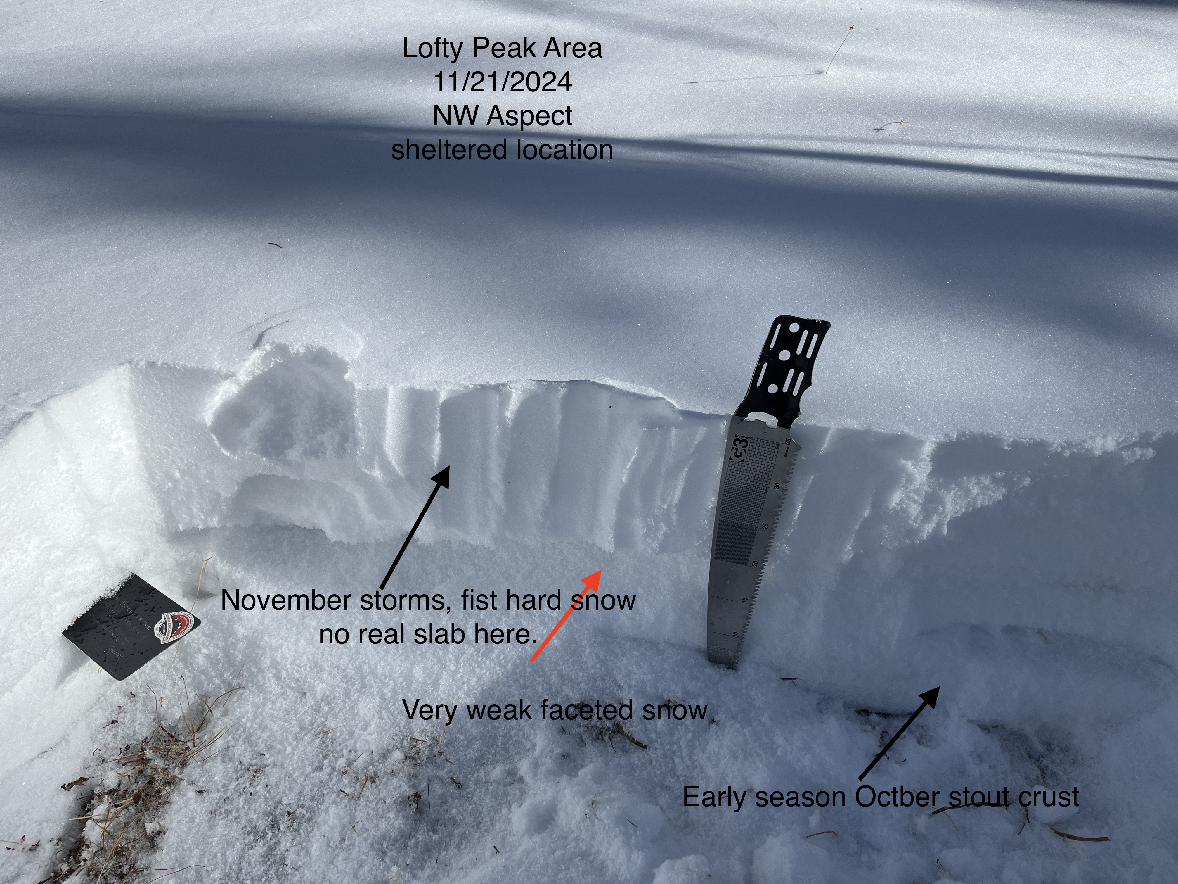
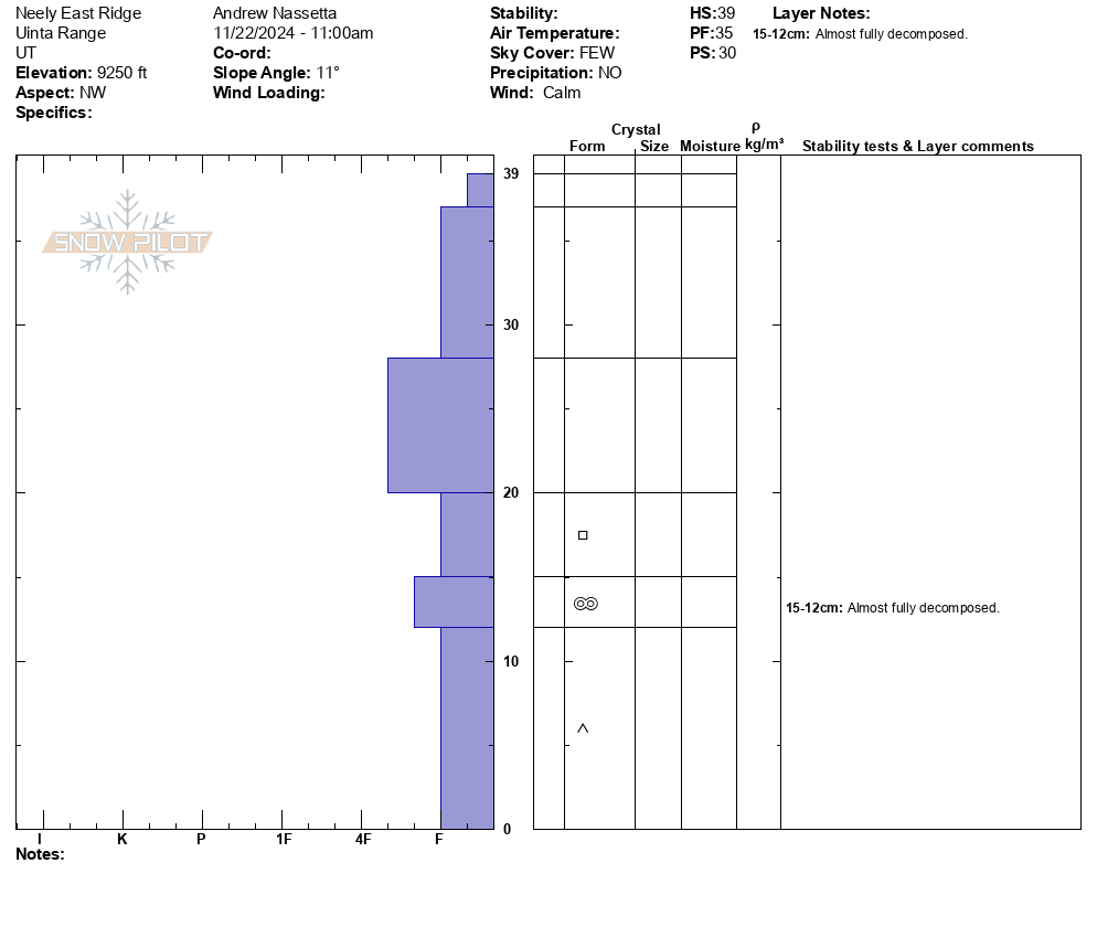
Moving around the Duchesne Ridge area today, I made note of varying snow depths and snow surfaces. Total snow depths ranged from 20-60cm (10-24”) and were supportable in areas where the pack is deepest, but felt sugary and weak where it was shallow. A crust developed on solar aspects this past week, while on the shady aspects, the snowpack continued to weaken and facet with cold, clear nights and mild days. Ted was near the north slope and noticed the snowpack lacking a slab and becoming very weak from top to bottom. See here for more about his observation or click here for all observations!
Where I was on the south half of the range, you can see the structure is similar, weak overall.
Recent Avalanches
No significant avalanche activity has been reported from the Western Uinta Mountains since Friday, November 15th, 2024.
Ad
Avalanche Problem #1
Normal Caution
Type
Location
Likelihood
Size
Description
Avalanche conditions are generally straight-forward, but we’re beginning to see the building blocks of our winter pack materialize. When I am heading out, here’s a few things I’m keeping my eye on:
Wind-Drifted Snow | As the weekend storm evolves, avalanche conditions will also change. I suspect new, storm snow will conspire with west and southwest winds and may form drifts that’ll react to our additional weight. So be sure to look for and avoid steep, wind-drifted slopes. Remember, these often look like rounded pillows and can sound hollow underneath our skis, feet or sleds.
Here’s where things get tricky: you’re most likely to find the hazard where the best skiing and riding exists… in upper-elevation terrain, especially on slopes facing the north half of the compass.
Additional Information
The Uinta weather station network was upgraded this summer and all that real-time info is found here. Simply click on "Western Uinta" tab and then "Weather Stations" tab.
We are always looking for snow and avalanche observations or just general riding conditions. So... if you see something, say something.
We are always looking for snow and avalanche observations or just general riding conditions. So... if you see something, say something. You can reach us directly by contacting Craig Gordon at craig@utahavalanchecenter.org -- 801-231-2170 or Andrew Nassetta at andy@utahavalanchecenter.org -- 860-460-8142.
General Announcements
Issued on Friday, November 22nd at 04:00 PM, this forecast expires 24 hours after the date and time issued, but will be updated this week as conditions change!
This forecast is from the U.S.D.A. Forest Service, which is solely responsible for its content. This forecast describes general avalanche conditions and local variations always occur.